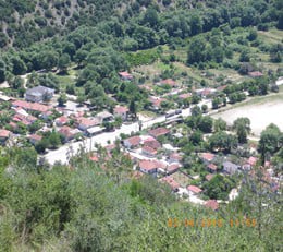
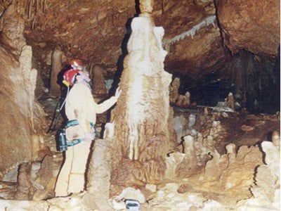
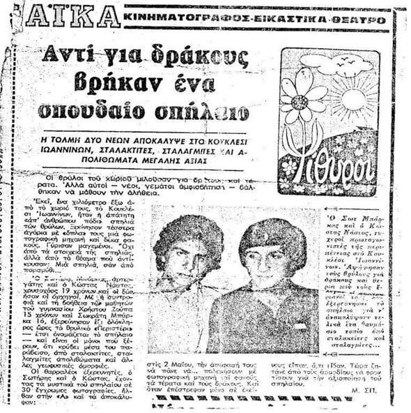
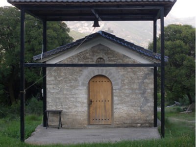
Kouklesi is a traditional village of Epirus, located in the regional unit of Ioannina, near the border with the prefecture of Preveza. It lies south of the city of Ioannina and consists of two settlements: the old village of Kouklesi and the newer settlement of Kato Kouklesi, also known as Potamia, formerly called “Keli.”
Today, the administrative center of the community is Kato Kouklesi, which is also the larger settlement.
Old Kouklesi is built on a small plateau, on the foothills of Mount Kouklesitiko and Morizi, east and lower than the southern ridge of Mount Olytsikas (Tomaros).
Its houses and neighborhoods are scattered across natural terraces, gentle slopes, and flat areas, forming an authentic mountain settlement that blends harmoniously with the surrounding landscape.
Around the historic core of the village lie important religious and historical landmarks, such as the Church of Agios Nikolaos (a former monastery), old wells, and dry-stone walls — clear signs of the area’s traditional agricultural and pastoral way of life.
During the interwar period and especially after World War II, the once scattered settlement gradually began to concentrate in more accessible locations. At the same time, Kato Kouklesi started to develop near the main road and the Louros River.
Despite these changes, small neighborhoods such as “Kiafa,” “Toka,” and the remote area known as “Sto Vouno” remain inhabited to this day, preserving the memory and spirit of the old village.
Kato Kouklesi is built on the right bank of the Louros River, at the foothills of Mount Kouklesitiko, alongside the Ioannina–Arta national road. Most houses are gathered around the old caravan inn (Hani) and the Church of Agios Sozontas, while the settlement has expanded eastward, closer to the river.
The village lies at the bottom of a striking gorge between Mount Olytsikas to the west and Mount Xirovouni to the east. Above the Klisoura tunnel, imposing rock formations rise dramatically, giving the area exceptional natural and geological interest.
This gorge is identified with the ancient Charadros, where a city of the same name existed in antiquity.
Kouklesi borders:
• to the north with Mousiotitsa and Terovo
• to the south with Kleisoura and Voulitsa Panagia
• to the east with Pente Pigadia
• to the west with the Olytsikas mountain range
The distance from Ioannina is approximately 38 kilometers.
The elevation of Old Kouklesi reaches 650 meters, while Potamia (Kato Kouklesi) lies at an elevation of approximately 120 meters.
The total area of the community is about 17 square kilometers, characterized mainly by mountainous terrain, extensive grazing lands, forested areas, and limited arable land.
Today, most building and agricultural activity is concentrated in Potamia, where small farms, gardens, orchards, and fruit trees dominate the landscape.
The Church of Agios Nikolaos is the oldest surviving building in Kouklesi and one of the most important historical and religious monuments in the wider area.
According to the date carved in stone above the sanctuary doorway (the apse of Agios Dimos), the church was built around 1806, placing its construction in the early 19th century.
Local oral tradition connects Agios Nikolaos with the era of Ali Pasha of Tepelena.
Stone masons from Kouklesi are said to have worked on the construction projects of the castle and baths of Ioannina. When they asked for permission to return to their village in order to repair their church, Ali Pasha allowed them to leave — but kept them under close watch.
When he later learned that the craftsmen had begun rebuilding the church in Kouklesi, he sent one of his men to confirm whether a church was indeed being erected. The masons answered truthfully — but they never returned to Ioannina.
Thus, Agios Nikolaos was completed and remained in the village as a powerful symbol of faith, freedom, and collective memory.
The church is built on a low plateau on the western side of the old settlement, slightly higher than the surrounding basin and close to the old village wells. In earlier times, the area was densely wooded, with oak trees, elms, kermes oaks, and other native species. To the north were the cells and facilities of the former monastery.
From the present village center, Agios Nikolaos appears almost attached to the rocky slope of Mount Olytsikas, fully integrated into the natural landscape.
Agios Nikolaos is a simple basilica with a dome over the main nave.
The roof of both the nave and the sanctuary rests on vaulted structures and is covered with stone slabs (schist). The narthex, under the same roof, does not have a vault but a wooden framework made from local trees, designed to support the heavy stone roofing.
On the southern side extends the old chagiati (covered portico), supported by rectangular stone-built columns with low enclosures. Later interventions did not alter the original form of the church.
Externally, the sanctuary apse is decorated with seven blind arches. The central arch contains the sanctuary window, while at the top of the stone the construction date is clearly visible.
The windows are small and narrow, the doors low and arched, and the floor is paved with large stone slabs — preserved in their original form to this day.
All construction materials originate exclusively from the local area:
• Stone, corner blocks, and lintels from local rock formations
• Roofing slate from the area known as Groppa
• The characteristic red stone from the location Drouskala
• Lime produced in the village’s traditional lime kilns
• Timber from oak, elm, and holm oak trees
The careful selection of these materials reflects the knowledge, self-sufficiency, and high level of craftsmanship of the local builders.
Above the western entrance of the main nave, the original inscription of the church’s icon painting has been preserved.
The church was frescoed in February 1849 by the brothers Ioannis, Nikolaos, and Matthaios, icon painters from Chionades in the province of Agios Vellas.
At that time, the village belonged ecclesiastically to the Metropolis of Ioannina, under Bishop Ioannikios.
The icon screen (iconostasis) is considered a notable example of Byzantine ecclesiastical art.
Its construction is attributed to a donation by Efthymios Zikos (known as Thymios), from Zorista, son of the renowned Zikos Michos.
Although the exact year of the donation is unknown, it is believed to have taken place after 1849 and before 1854.
The woodcarver of the icon screen remains unknown, as was often the case during that period.
Closely connected to the church was the Monastery of Agios Nikolaos.
There are no written sources regarding its foundation, but oral tradition speaks of a period of significant prosperity, extensive water facilities, and notable economic activity.
The monastery buildings (cells, enclosures) were located south of the church, on the same slope, separated by a dry ravine that is still visible today.
The old School was originally a monastic building and formed part of the broader “Ai-Nikolas” complex.
During the Greek War of Liberation (1912–1913), the School was completely destroyed, and the church was looted, though not burned.
The Ecclesiastical Committee recorded the damages and submitted a report to the Metropolis of Ioannina on May 1st, 1913.
The total damage was estimated at 5,660 drachmas, revealing the wealth and importance of both the church and the monastery to the region.
Agios Nikolaos of Kouklesi is not merely an old church.
It is a living testimony to the faith, craftsmanship, and historical journey of the village, deeply bound to the landscape and the collective memory of its people.
Early stages of scientific research have shown that Peristeri Cave contains horizontal chambers and other speleological features of exceptional scientific value.
The cave lies within the same geological formation as the Achelous River area, increasing its geological significance and the need for careful study.
According to the findings of speleologist Antonis Bartzokas, the cave likely consists of successive chambers, descending gradually toward the base of the gorge, in the area of Platanakia and the lower part of the ravine.
Both the researcher and the local community recognize the importance of continuing exploration. Efforts are underway to secure funding and collaborate with public and scientific institutions so that systematic and safe research can proceed.
There is strong optimism that Peristeri Cave will soon be more thoroughly explored and recognized as a site of major scientific value, worthy of inclusion among the most significant documented caves in Greece.
The small church of Agios Sozontas, located in Kato Kouklesi (Potamia), is considered one of the earliest buildings of the settlement and closely connected with the first phase of habitation in the area.
It is built on slightly elevated ground near the gorge and close to the river. The surrounding landscape is rugged, with rocky formations, olive trees, and natural slopes that integrate the church seamlessly into its environment.
The church is modest in size and construction, reflecting the needs and capabilities of the local community during its early years. According to tradition, it originally served as a place of worship for the first inhabitants who settled in the lower part of the village.
Architecturally, Agios Sozontas is simple and unpretentious. Over time, repairs and small interventions were made in order to preserve the building, without altering its original character.
The church remains an important landmark for Kato Kouklesi and a symbol of the village’s early settlement, religious life, and connection to the surrounding.
The location where the Church of Agios Sozontas was built was not chosen at random. Its construction at this specific point also served a practical purpose, as it marked the eastern boundary of the village, toward Terovo and the Kleisoura area.
According to local tradition in Kouklesi, Agios Sozontas once lived on Mount Xirovouni as a shepherd. The Turks captured him and tried to force him to convert to Islam, but he refused to renounce his faith. He was eventually killed, and the Christian community honored him as a saint.
While he worked as a shepherd, Agios Sozontas would send his sheep to graze from Mount Olytsikas. For this reason, churches dedicated to Agios Sozontas are found both in Kouklesi and higher up on Mount Xirovouni, near the upper settlement.
This is what local oral tradition recounts. However, according to the short hagiography preserved in the church, Agios Sozontas was a Christian martyr from Lycaonia, who suffered martyrdom during the reign of Emperor Maximian. His secular name was Tarasios. He cut off the arm of a golden statue of Artemis in Cilicia, broke it into pieces, and distributed them to the poor. For this act, he was arrested and had his bones crushed. The Orthodox Church commemorates him on September 7.
During the Greek War of Liberation (1912–1913), the Church of Agios Sozontas in Kouklesi possessed significant ecclesiastical property. This is documented in an official report submitted by the Ecclesiastical Committee to the Metropolis of Ioannina on May 1st, 1913.
The reported damages included:
- Sacred vessels valued at 50 drachmas
- Vestments valued at 60 drachmas
- 5 icons valued at 110 drachmas
- A censer valued at 10 drachmas
- 21 ecclesiastical books valued at 150 drachmas
- 10 okas of candles valued at 100 drachmas
- 350 olive trees valued at 3,500 drachmas
- An altar cloth valued at 30 drachmas
The total estimated damage amounted to 4,010 drachmas, highlighting the importance and prosperity of the church at that time.
A cemetery also existed in the area and appears to have been used during the earliest period of settlement. According to local elders, those who could not be transported to the upper village were buried here.
Today, Agios Sozontas retains approximately 300 olive trees as ecclesiastical property. In the past, the number exceeded 500, but significant losses occurred during World War II.
During the conflicts of the 20th century, many military transport vehicles stationed near the old chapel were destroyed.
In the early 1990s, next to the old chapel of Agios Sozontas, a new church dedicated to the same saint was built through the financial contribution of the local residents. The new church is larger and more accessible, although construction works have not yet been fully completed.
The old church of Agios Nikolaos, however, suffered significant structural damage over time. It developed serious cracks and is in danger of collapsing due to separation at the base of its dome. For this reason, supporting retaining walls are required in order to preserve the oldest monument of the village. The people of Kouklesi continue to make efforts toward this goal.
At Agios Sozontas, a small annual festival was traditionally held every September 7, especially during the interwar period.
During one of these celebrations, a tragic incident occurred — an accidental shooting. According to local accounts, the victim was a man named Christakis, who was fatally wounded by a gunshot, reportedly fired by Giorgos Tasis or possibly another individual. After this incident, the festival gradually ceased.
At Easter, the traditional Kagkelari dance, accompanied by songs, took place outside the courtyard of Agios Nikolaos, in a small open area (farmland) below the church and near the tall plane trees.
In the same location, traditional Lambrian games were also played, such as Vathes, Geraki, Touras, Black Donkey, and Papadia, preserving elements of local folk culture and communal life.
The chapel of Agios Ilias is located on the mountain above the village.
Every year on July 20th, the feast day of Prophet Elijah, the village’s traditional festival takes place.
In the past, after the Divine Liturgy, dancing followed at the chapel, and later in the evening the main celebration was held in the village center, with participation from locals and visitors from nearby villages.
The festival continues to this day, both in Upper and Lower Kouklesi.
Although Agios Nikolaos is the patron saint of Kouklesi, Agios Ilias remains deeply connected to local tradition and festive life.
The chapel of Agios Georgios is celebrated annually on Saint George’s feast day.
In earlier times, the celebration included a blessing of waters and traditional dancing in the chapel courtyard, preserving the springtime gathering custom of the villagers.
From this location, on clear days, one can see as far as Preveza and Lefkada
Kouklesi possesses a distinct natural beauty, equal to far more advertised destinations.
A network of over 30 kilometers of dirt roads and trails allows visitors to explore the landscape on foot.
Over the years, mountaineering and hiking clubs have visited the area and been impressed by its untouched nature.
The routes include forest paths, natural springs, and trails starting from the Louros River and reaching as far as Trypa Tsaousas.
It is an ideal landscape for walking and exploration — authentic, quiet, and unspoiled.
Near the village of Agios Georgios, at a distance of about 14 kilometers, you will find the Roman aqueduct and the entrance of Kokkinopylos. In the Municipality of Ziros, near Philippiada, there is Lake Ziros at a distance of 20 kilometers, and at the sources of Louros you will find Lake Viros at a distance of 11 kilometers. Before reaching Ioannina, at a distance of 30 kilometers, you will find the Vrellis Museum, while about 15 kilometers from Kouklesi there is the War Museum.
Thanks to its remarkable preservation through the centuries, Ancient Nicopolis offers today’s visitor a rare opportunity to admire Roman architecture and urban planning. Yet, the monument that continues to impress the most is its aqueduct—a unique engineering achievement of its time.
The aqueduct was part of an extensive 50-kilometer network that brought water from the springs of the Louros River, supplying the city with sufficient water and supporting a population estimated at around 150,000 inhabitants.
Nicopolis was founded in 31 BC by Octavian Augustus, as a symbol of his decisive victory at the Battle of Actium over Mark Antony and Cleopatra. The city became a major administrative and political center, playing a key role in the Romanization and control of western Greece.
Although the aqueduct may have been initiated during the time of Augustus, most modern scholars date its construction to the 2nd century AD, during the reign of Hadrian. Before its completion, residents relied on wells and small springs for water.
The structure combined arched bridges, underground channels, surface conduits, and a tunnel carved through the hills of Kokkinopylos, overcoming an elevation difference of about 80 meters with impressive precision. The water was transported to two main reservoirs at the Nymphaeum of Nicopolis, from where it was distributed throughout the city.
Remains of the aqueduct are still visible at various points along its route, allowing visitors to appreciate the Romans’ advanced knowledge of hydraulics, topography, and engineering. Maintenance works are known to have taken place around 350 AD, and the aqueduct likely remained in use into the early Byzantine period, before being abandoned after destructive invasions in the 6th century.
Ancient Nicopolis is located 8 km north of Preveza, on the peninsula between the Ambracian Gulf and the Ionian Sea, with easy access via the Preveza–Ioannina national road.
Sections of the aqueduct can be visited at several locations along its route, including Archangelos, Stefani, Skala of Louros, and especially near the Louros springs, in today’s village of Agios Georgios, just north of Filippiada.
Kokkinopylos is a unique geological, natural, and archaeological phenomenon in the Balkan Peninsula.
Clay, nature, and time have worked together to create a true “small miracle” in the heart of the Regional Unit of Preveza.
It is an impressive complex of hills within the administrative boundaries of the Municipality of Ziros, forming a landscape that feels almost lunar and otherworldly. Anyone who walks across this terrain and explores the hills experiences a scenery unlike anything else in the region.
Researchers believe that the formation dates back to prehistoric times. Visitors find themselves wandering among small hills and ravines of deep red color, in a distinctive “red earth” (terra rossa), as it was described by Spanish travelers.
It is a landscape where Franz Kafka’s phrase, “Anyone who keeps the ability to see beauty never grows old,” seems to find perfect expression.
Of particular importance are the archaeological findings from the Palaeolithic and Bronze Age, discovered at the site of Asprochaliko, very close to Kokkinopylos, confirming the long-standing human presence in the area.
Kokkinopylos can be reached from two different access points:
From the Preveza–Ioannina National Road
You can park near the village of Agios Georgios and walk for approximately 500 meters to reach the hills.
From the Lake Ziros – Rizovouni – Stefani Provincial Road
Leave your car at the point marked “to Kokkinopylos” and follow a forest hiking trail of about 1.5 km, which leads directly to the Kokkinopylos landscape.
Lake Ziros, also known as Lake Ziros, is located in eastern Preveza Regional Unit and is an authentic natural monument, with a beauty comparable to lakes of Central Europe and North America.
To the west rise the Thesprotian mountains, while very close to the eastern side flows the Louros River, with which the lake is connected through underground channels. Slightly to the north lies Kokkinopylos, an impressive group of red-clay hills of significant geological and archaeological interest.
According to scientific estimates, Lake Ziros was originally covered, meaning it was once a cave whose roof collapsed about 10,000 years ago, forming the lake as we see it today.
With a length of approximately 900 meters and a width of 600 meters, the lake’s waters create a natural “mirror,” offering visitors a unique spectacle within a lush green environment. Thousands of species of flora and fauna compose a setting ideal for relaxation, wellness, outdoor activities, and enjoyment of nature. Essentially, it is a natural park, shaped entirely by the forces of nature.
The name of the lake is believed to be of Slavic origin, reflecting the medieval presence of different populations in Epirus and highlighting the historical depth of the wider area. The buildings of the former Children’s Village, located north of the lake, are also reminders of a difficult period in modern Greek history, the Greek Civil War.
Lake Ziros also holds an important place in local folklore. According to a traditional legend, its creation is linked to the story of two brothers and an angel, a tale reminiscent of Sodom and Gomorrah, passed down from generation to generation.
- Easy access by car
- Ideal destination for cycling, picnics, hiking, relaxation, and light exercise
- Only 2 km from the town of Philippiada
- A restaurant–café operates on the eastern shore, offering panoramic lake views
- Opportunities for alternative activities (canoe–kayak, archery, etc.)
- During the summer months, the Zero Festival, a music and cultural event, takes place
- An Environmental Education Center operates at the lake
If you are looking for a destination that impresses with unspoiled natural beauty, the Louros Springs and Lake Virou are exactly what you need. Often referred to as the “Blue Lake” of Ioannina, the springs of the Louros River are a true gem of Epirus—still relatively unknown to most travelers.
Lake Virou – A Dreamlike Setting
Just a few kilometers outside Ioannina, near the village of Vouliasta and along the road toward Arta, lies Lake Virou.
The scenery feels as if it were painted on a canvas: crystal-clear turquoise waters that change shades depending on the light and the mood of the sky.
At an elevation of 296 meters, this small lake—about 93 meters in diameter and with a maximum depth of 10 meters—feeds the Louros River with crystal-clear waters emerging from deep underground. The result is a near-perfect natural pool, offering a truly enchanting sight.
The area is ideal for those seeking peace and a break from everyday life. Dense vegetation surrounds the lake, making it perfect for leisurely walks, picnics in the shade, and moments of absolute tranquility. The more adventurous may attempt a dip in the cold waters, although the depth and low temperature make the lake better suited for admiration rather than swimming.
Rising from Mount Tomaros, the Louros River flows for about 80 kilometers before reaching the Ambracian Gulf. Along its course, it passes through gorges, forms small lakes, and irrigates fertile plains, supporting a rich ecosystem of flora and fauna.
The importance of the Louros has been known since antiquity. It served as a major source of water for important ancient cities, including Ancient Nicopolis, one of the largest cities of ancient Greece.
A key historical monument of the area is the Roman aqueduct, built in 31 BC by Octavian Augustus, parts of which are still preserved today near the village of Agios Georgios.
The Pavlos Vrellis Museum of Greek History, also known as the Wax Figures Museum, is located near Ioannina, in Epirus. Created entirely by the sculptor Pavlos Vrellis, the museum opened to the public in 1995 and is the most renowned museum of its kind in Greece.
It features around 150 life-size wax figures arranged in 36 historical scenes, covering 24 centuries of Greek history, from antiquity to World War II. The exhibits are set in carefully recreated environments—mountains, caves, houses, and churches—offering visitors an immersive journey through Greek history, with special emphasis on Epirus.
- Doulas Dimitra Pharmacy Kerasonas prevezis
- Doumas Evangelos Pharmacy chani terovou
- Lainas Supermarket panagia prevezis
- Giannis Supermarket kerasonas
- Chani Supermarket chani terovou
In Kouklesi
- Café
- Grocery store
- Grill house O Paradeisos
In nearby villages (Chani Terovou – Nea Mousiotitsa – Panagia – Kerasovas)
You will find restaurants, grill houses, and cafés. Indicatively:
- Synantisi
- Dipla sto Potami
- Mageirakos
- O Platanos
- O Mylos